Images
The images in this library were largely taken during GSCI research projects by staff or individuals involved in our research. These are a small selection of the more than 5,000 photographs currently on file. We hope to make more available in the future as we digitize our photo collection. Please note that the photographs included in the History section may also come from Archival and/or published works not generated by GSCI. Please credit the photographer and source of all photographs as indicated.
Copyright notice
These on-line images may be used for research and non-commercial purposes only, with the understanding that the photographer and source will be credited as noted. Photographs may not be reproduced in published works or used in public broadcasts without the written permission of the Gwich'in Social & Cultural Institute.
Filter by categories

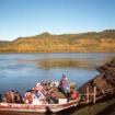
Alestine Andre's fish camp at Diighe'tr'aajil (near Tree River) on the Mackenzie River. Margaret Mitchell, James Cardinal and Alestine Andre in camp, with Erika Kritsch walking up hill in...
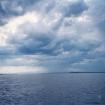
Łìidlaii, (a.k.a The Forks) of the Arctic Red River, where the Arctic Red and Cranswick rivers meet
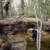
Gabe Andre and George Niditchie examining the unique geography of Nèhtrùh Chì’ along the Arctic Red River during the 1993 Gwichya Gwich'in Place Names Project.

Nap Norbert looking at Tithegeh Chì' also called Gwi’eekajìlchit, a striking cliff face on Campbell Lake in the Gwich'in Territorial Park near Inuvik
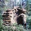
Remains of the chimney from the Roman Catholic mission house at Teetshik Goghas (a.k.a. Old Arctic Red).
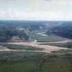
Aerial view of Gyuu Dazhoo Njik (Snake River) during the 1993 Gwichya Gwich'in Place Names Project. Note fires burning along the river.
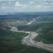
Srehtadhadląįį (Point Separation) where the Mackenzie River separates into three main channels which then flow through an area known as the “Mackenzie Delta.”
View of hills at Tł’oondih where summer and winter trails led to hunting grounds in the Yukon. Clearing is where Old Vittrekwa had his camp. Photo taken during the 2001 Gwich'in Science Camp.
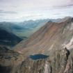
Lake in the upper reaches of the Blackstone River. Photo taken during the 1999 Tombstone Oral History Project, a partnership between GSCI, Teetl'it Gwich'in Council, Tr'ondek Hwech'in and Yukon...
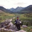
Walter Alexie standing beside a hunting blind in Seela Pass with the Chandindu River behind him. Photo taken during the 1999 Tombstone Oral History Project, a partnership between GSCI, Teetl'it...


